
Routes
Happiness Road, Ha Giang: Route, History and Riding Guide
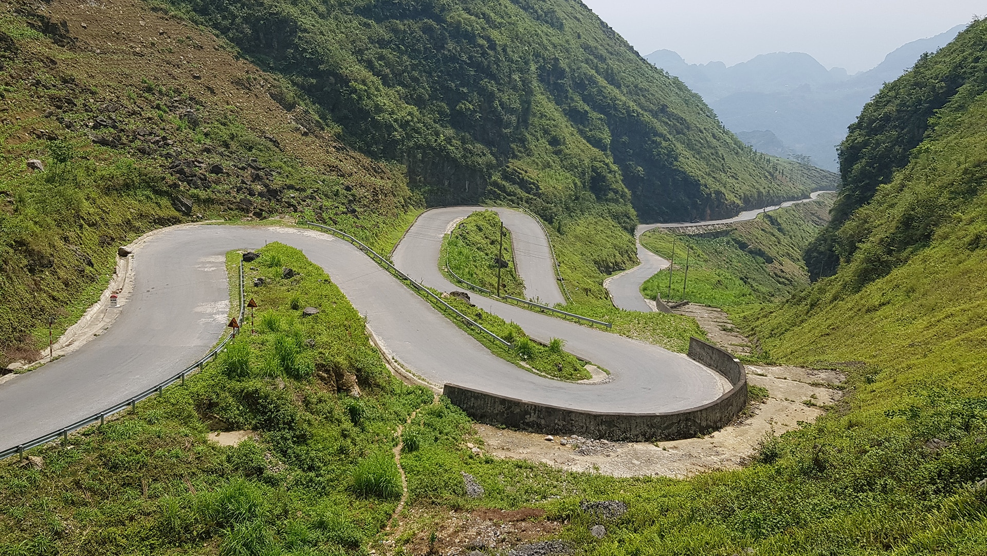
Happiness Road is one of the best-known mountain roads in Northern Vietnam. It runs from Ha Giang City through Quan Ba, Yen Minh and Dong Van before reaching Meo Vac, crossing some of the most dramatic scenery in the province.
Today it forms the backbone of most Ha Giang Loop itineraries, but the road is more than just a scenic ride. Its construction changed travel through the highlands and connected communities that had previously been extremely difficult to reach.
If you are planning to ride it yourself, start with our Vietnam Motorcycle Route Maps. The individual route pages let you look at each part of Happiness Road separately, compare alternatives and work out realistic riding times before you leave.
| Details | |
|---|---|
| Route | Ha Giang City – Quan Ba – Yen Minh -Dong Van – Meo Vac |
| Approx distance | About 185km |
| Road type | Mountain roads, passes, valleys and karst plateau |
| Best riding plan | Split over 3-4 days |
| Main Highlights | Quan Ba, Yen Minh, Dong Van, Ma Pi Leng, Meo Vac |
| Traffic | Light to moderate, busier on popular sections |
| Road Conditions | Mostly paved, but roadworks and damage are possible |
| Best for | Scenic touring and first time Ha Giang riders |
| Main concerns | Weather, fog, landslides and slow mountain traffic |
Why Happiness Road Matters
Before Happiness Road was completed, travelling between Ha Giang City and the highland districts could take several days on foot or by cart. The new road connected Quan Ba, Yen Minh, Dong Van and Meo Vac much more directly with the provincial capital and changed everyday life across the region.
Construction began in 1959 and continued until 1965. More than a thousand local workers and volunteers took part, often working through extremely difficult mountain terrain with very limited machinery.
The result was much more than a transport route. It improved access to trade, education and services and eventually became the road that now carries most visitors through the Dong Van Karst Plateau.
Riding Happiness Road from Ha Giang to Dong Van
This strip of road (185Km) connects then Ha Giang Town (now city) to the remote districts of Quan Ba, Yen Minh, Dong Van and Meo Vac. It is said that the road was built with the aim of helping the highlanders gain access to the plains. However, the cynic in me suggests that it was all about getting the rich mineral deposits from the highlands for the benefit of the lowlanders.
It would be without doubt that better communication links brought prosperity and a slow rise in living conditions to the highlanders. Interestingly, it wasn’t really until 2010 when the Ministry of Tourism really began to promote the Province that conditions really began to improve at any pace.
Before the road was built, there was obviously a route but it took many days on foot or by cart to get from Meo Vac to Ha Giang. The road improved this immensely. Happiness road certainly has enabled the highlanders to improve their lives at a much faster rate than if it wasn’t there.
Ha Giang City to Quan Ba
The first section north from Ha Giang City is relatively straightforward before the road starts climbing more seriously into the mountains. As you approach Quan Ba, the landscape changes quickly and the wider valleys give way to steeper passes and mountain viewpoints.
For the first part of the journey, use our Ha Giang to Quan Ba route map. This is a useful section to ride slowly because it is often the first proper mountain riding of a Ha Giang trip.
Quan Ba also works well as a natural place to stop, have coffee or take a break before continuing towards Yen Minh.
Quan Ba to Yen Minh
The road from Quan Ba to Yen Minh has a different feel. There are pine forests, wider valleys and small mountain settlements, and the riding is usually enjoyable without feeling too demanding.
This section also gives you some route choice. Our Quan Ba to Yen Minh motorcycle route map shows the main options and helps you decide whether you want the most direct road or a more scenic alternative.
Yen Minh is a useful overnight stop if you want to divide Happiness Road into easier days. It also puts you in a good position to take your time on the more dramatic highland roads the following morning.
Yen Minh to Dong Van
From Yen Minh, the landscape becomes increasingly rocky as you enter the Dong Van Karst Plateau. The road climbs higher, the limestone becomes more dominant and the scenery starts to feel much more like the Ha Giang people imagine before they arrive.
The Yen Minh to Dong Van route map is particularly useful because there is more than one worthwhile way to make this journey. It is worth checking the alternatives rather than simply accepting the first route your phone suggests.
There are also worthwhile side trips in this area. If you are planning to visit the far north, you can compare the Yen Minh to Lung Cu route or continue to Dong Van first and use the Dong Van to Lung Cu route map as a separate excursion.
Dong Van is one of the easiest places on the loop to stop overnight. There is plenty of accommodation and food, so there is very little reason to rush this part of Happiness Road just to reach Meo Vac earlier.
Dong Van to Meo Vac and Ma Pi Leng Pass
The road from Dong Van to Meo Vac is probably the most famous section of Happiness Road. It crosses Ma Pi Leng Pass high above the Nho Que River and Tu San Gorge, and the views are some of the most impressive anywhere in Northern Vietnam.
The distance is short, but this is a perfect example of why kilometres are not a good way to judge a riding day in the mountains. The Dong Van to Meo Vac route map may show a relatively short ride, but viewpoints, traffic, photographs and stops can easily turn it into half a day.
This is also one of the busier parts of the Ha Giang Loop. Ride steadily, expect buses and other motorcycles around blind corners, and leave enough space to stop safely when the road becomes crowded.
Road Conditions, Weather and Riding Time
Road Conditions and Safety
Happiness Road is mainly paved, but the condition of a mountain road can change quickly. Roadworks, broken surfaces, small landslides and loose gravel are all possible, particularly after heavy rain.
Fog can also be a bigger problem than the road surface itself. On the higher sections around Dong Van and Meo Vac, visibility can change very quickly and a road that felt easy half an hour earlier can suddenly require much more concentration.
The best approach is simply to keep the pace conservative. Do not ride according to the speed you think the road should allow; ride according to what you can actually see ahead.
When Is the Best Time to Ride?
Happiness Road can be ridden during most of the year, but the experience changes considerably with the season. Spring and autumn usually offer comfortable temperatures and good general riding conditions.
Summer is warmer and greener, but heavy rain increases the chance of landslides, damaged surfaces and poor visibility. Winter can bring some very clear mountain days, but mornings around Dong Van and Meo Vac can be surprisingly cold.
Whatever month you choose, check the weather shortly before riding. Mountain conditions in Ha Giang can be very different from the weather in Hanoi.
How Long Should You Allow?
You could technically ride from Ha Giang City to Meo Vac in one long day, but there is very little reason to do that unless you are simply trying to cover distance. Happiness Road is much better when it is broken into shorter stages.
Two days is workable, while three days gives you much more time for viewpoints, food stops, small detours and unexpected delays. If you are deciding how to build the overall trip, compare our Ha Giang 3-Day Loop and Ha Giang 4-Day Loop before choosing.
The four-day version is usually more relaxed because you are not constantly trying to keep moving. In Northern Vietnam, finishing early and having time to explore is normally better than arriving after dark because an itinerary looked short on paper.
Where to Go After Meo Vac
Meo Vac does not have to be the end of the journey. From here you have two very useful directions, and they lead to quite different trips.
If you are continuing the traditional Ha Giang Loop, the Meo Vac to Du Gia route map takes you south towards one of the most popular overnight stops on the loop. From Du Gia you can then continue back towards Ha Giang using the Du Gia to Ha Giang route map.
If you have more time and want to continue east into Northeast Vietnam, use the Meo Vac to Bao Lac route map. From Bao Lac you can carry on towards Cao Bang using the Bao Lac to Cao Bang route map.
Happiness Road can therefore be the backbone of a short Ha Giang Loop, but it can also be the beginning of a much larger journey through Northeast Vietnam.
If Ha Giang is only one part of your trip, you can also connect towards Ba Be using the Ha Giang to Ba Be Lake route map. The main Vietnam Motorcycle Route Maps page lets you move between these routes and build the trip one section at a time rather than trying to plan everything from one Google Maps screen.
For riders starting and finishing in the capital, our Hanoi motorcycle rental page covers the bikes available for independent trips. If you prefer us to organise the route and accommodation, you can also look through our motorcycle tours.
7-Day Due North Motorcycle Tour
Ride deep into Vietnam’s northern frontier: mountain passes, hidden valleys, and rich history packed into one unforgettable week Book NowFAQ
Is Happiness Road the same as the Ha Giang Loop?
Not exactly. Happiness Road is the main road running from Ha Giang City through Quan Ba, Yen Minh and Dong Van to Meo Vac. The Ha Giang Loop usually continues beyond Meo Vac through places such as Du Gia before returning to Ha Giang.
How long does it take to ride Happiness Road?
You could cover the full road in one long day, but two or three days is much better. The distances are not huge, but viewpoints, mountain roads, traffic and stops make the riding slower than it looks on a map.
For a wider itinerary, compare the Ha Giang 3-Day Loop and Ha Giang 4-Day Loop.
What is the best part of Happiness Road?
For many riders, the section from Dong Van to Meo Vac across Ma Pi Leng Pass is the highlight. It has some of the biggest mountain views on the route and looks down towards the Nho Que River.
The Dong Van to Meo Vac route map shows this section in more detail.
Can I continue from Meo Vac to Cao Bang?
Yes. A very useful connection runs from Meo Vac to Bao Lac and then onwards towards Cao Bang.
Start with the Meo Vac to Bao Lac route map and then continue with the Bao Lac to Cao Bang route map.
Do I need a guide to ride Happiness Road?
Many experienced riders travel independently, but good route planning is important. Weather, road conditions and mountain riding can all affect the day, so check conditions before leaving and allow more time than the distance alone suggests.
Our Vietnam Motorcycle Route Maps are designed to help independent riders compare the different sections before setting off.
More Than Just a Scenic Road
Happiness Road deserves its reputation as one of Vietnam’s great mountain roads, but its importance goes much further than the views from Ma Pi Leng. It connected remote communities and changed travel through the Ha Giang highlands long before motorcycle tourism arrived.
For riders today, the best way to enjoy it is not to treat the road as one long ride from Ha Giang to Meo Vac. From there, you can return through Du Gia, continue east towards Cao Bang or connect the ride into a much larger Northern Vietnam journey.
Break it into sections, allow more time than the distance suggests and use the individual Vietnam Motorcycle Route Maps to decide where you want to stop, what you want to see and where you want to go next.